
Thank you for supporting this site ❤️
Make a donation
Make a donation
Gear up for your next adventure:
As an Amazon Associate, this site earns from qualifying purchases at no extra cost to you.
Tibú topographic map
Click on the map to display elevation.
Thank you for supporting this site ❤️
Make a donation
Make a donation
Gear up for your next adventure:
As an Amazon Associate, this site earns from qualifying purchases at no extra cost to you.
About this map
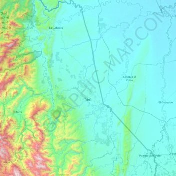
Name: Tibú topographic map, elevation, terrain.
Location: Tibú, Norte, Norte de Santander, RAP Gran Santander, Colombia (8.25180 -73.07414 9.14055 -72.46840)
Average elevation: 268 m
Minimum elevation: 3 m
Maximum elevation: 2,204 m
Thank you for supporting this site ❤️
Make a donation
Make a donation
Gear up for your next adventure:
As an Amazon Associate, this site earns from qualifying purchases at no extra cost to you.