
Make a donation
Gear up for your next adventure:
As an Amazon Associate, this site earns from qualifying purchases at no extra cost to you.
Riezlern topographic map
Click on the map to display elevation.
Make a donation
Gear up for your next adventure:
As an Amazon Associate, this site earns from qualifying purchases at no extra cost to you.
About this map
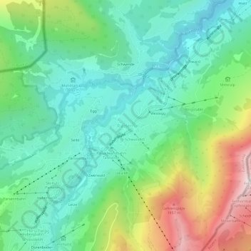
Name: Riezlern topographic map, elevation, terrain.
Average elevation: 1,270 m
Minimum elevation: 940 m
Maximum elevation: 2,028 m
Make a donation
Gear up for your next adventure:
As an Amazon Associate, this site earns from qualifying purchases at no extra cost to you.
Other topographic maps
Click on a map to view its topography, its elevation and its terrain.
Make a donation
Gear up for your next adventure:
As an Amazon Associate, this site earns from qualifying purchases at no extra cost to you.
Damüls
Austria > Vorarlberg > Bezirk Bregenz
Damüls is situated at an altitude of 1,430 m. It has an area of 20.92 km². It borders on the Bregenz Forest, the Biosphere Reserve Großes Walsertal, the Laternsertal, and all other Vorarlberg districts (Bludenz, Feldkirch and Dornbirn). The most famous mountain peak in the area, a popular hiking destination…
Average elevation: 1,608 m
Make a donation
Gear up for your next adventure:
As an Amazon Associate, this site earns from qualifying purchases at no extra cost to you.