
Make a donation
Gear up for your next adventure:
As an Amazon Associate, this site earns from qualifying purchases at no extra cost to you.
Kabul topographic map
Click on the map to display elevation.
Make a donation
Gear up for your next adventure:
As an Amazon Associate, this site earns from qualifying purchases at no extra cost to you.
Kabul
The modern-day city of Kabul is located high in a narrow valley in the Hindu Kush mountain range, and is bounded by the Kabul River. At an elevation of 1,790 metres (5,873 ft), it is one of the highest capital cities in the world. The center of the city contains its old neighborhoods, including the areas of Khashti Bridge, Khabgah, Kahforoshi, Saraji, Chandavel, Shorbazar, Deh-Afghanan and Ghaderdiwane.
Make a donation
Gear up for your next adventure:
As an Amazon Associate, this site earns from qualifying purchases at no extra cost to you.
About this map
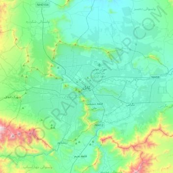
Name: Kabul topographic map, elevation, terrain.
Location: Kabul, Kabul District, Kabul Province, 1001, Afghanistan (34.36695 69.02506 34.68695 69.34506)
Average elevation: 1,938 m
Minimum elevation: 1,701 m
Maximum elevation: 3,000 m
Make a donation
Gear up for your next adventure:
As an Amazon Associate, this site earns from qualifying purchases at no extra cost to you.
Other topographic maps
Click on a map to view its topography, its elevation and its terrain.